


Mallorca Topo Maps
Descriere Mallorca Topo Maps
+++ Nou GPS de cartografiere App +++
Ușor de utilizat app în aer liber / offline navigare prin GPS, cu acces la cele mai bune hărți topografice și imagini aeriene pentru Mallorca.
++ Pentru utilizarea offline PRO caracteristici necesare! ++
Rândul său de telefon Andoid / tableta intr-un GPS în aer liber pentru excursii în Backcountry fără acoperire celulară. Această aplicație vă oferă opțiuni de cartografiere similare, așa cum s-ar putea de la Garmin sau știți Magellan GPS handheld-uri.
Inclus in straturi harta GRATUIT:
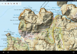
• Mallorca Topo Hartă: Nacional 1 SiteMap Topográfico: 50.000 și 1: 25.000 (IGN MTN25 & MTN50)
• Mallorca Baza Hartă: IGN Base Topografica Nacional 1: 25,000 (BTN25 & BCN25)
• Mallorca imagerie: de înaltă rezoluție imagini aeriene. Planul Nacional de Ortofotografía Aérea (PNOA)
• Registrul Cadastral Hartă: Cartografía Catastral
• OpenStreetMap: Aceste hărți crowdsourcing sunt un plus foarte util pentru alte straturi ale hărții. Conține multe caracteristici unice.
• OpenCycleMaps: Aceste hărți sunt ideale pentru a planifica excursii cu bicicleta
• ESRI Topografic
• Imagini ESRI aeriene
• ESRI Street Map
• Google Map Road (acces numai online)
• Imagini Google prin satelit (acces numai online)
• Google Map teren (acces numai online)
• Bing Road Map (acces on-line numai)
• Imagini Bing prin satelit (acces numai online)
• Pământ Noaptea
• suprapunere Hillshading
Caracteristici principale pentru exterior-navigare:
• Crearea și editarea Waypoints
• Goto-Waypoint-Navigație
• Înregistrarea Track (cu viteza, altitudinea și profilul de precizie)
• Tripmaster cu câmpuri pentru contorul de parcurs, viteza medie, rulment, altitudine etc.
• GPX / KML / KMZ Export
• Căutare (toponime, POI-uri, străzi)
• datafields personalizabile View Harta si Tripmaster (de exemplu Viteza, Distanta, Compass, ...)
• Waypoints Partajarea, Melodii sau căi (prin e-mail, Whatsapp, Dropbox, Facebook, ..)
• coordonatele de afișare în Lat / Lon, UTM sau MGRS / usng (Military Grid / US National Grid)
• Înregistrarea și distribuirea piese cu statistici și profil de altitudine
• Rotire hartă (Track Up & North Up)
• Get Elevation de lung click pe harta
• Track Reluare
• si multe altele ...
Pro Caracteristici disponibile: (Pro Caracteristici disponibile prin intermediul În App Purchase)
• utilizarea offline - nici o acoperire de celule necesare
• Ușor + Fast bloc-descărcare de harta pentru dale UTILIZARE OFFLINE (nu pentru Google și Bing Maps)
• Crearea și editarea Trasee
• Route-Navigație (punct-la-punct de navigare)
• GPX / KML / KMZ Import
• nelimitat Waypoints & Melodii
• Adăugați Harta celelalte placi de ceramica-Server
• Fără reclame
Offline Utilizare:
Toate dale hartă văzute sunt păstrate în memoria cache. Pentru a cache zone mari de care aveți nevoie pentru a achiziționa Pro caracteristici.
Utilizați această aplicație de navigație pentru activități în aer liber, cum ar fi drumeții, ciclism, camping, alpinism, echitatie, schi, canotaj, vânătoare, tururi 4WD offroad sau de căutare și salvare (SAR).
Adăuga puncte intermediare personalizate in format MGRS / usng longitudine / latitudine, UTM sau cu origine WGS84.
Import / Export / Share GPS-Waypointuri / Melodii / Trasee în format Google Earth KML / KMZ GPX sau.
Preîncărcați date harta gratuit pentru zone fără serviciu de celule (versiunea Pro!).
Comentariile și cereri de facilitati mallorcamaps@atlogis.com
Atunci o privire la alte aplicații noastre de navigare în aer liber: https://play.google.com/store/search?q=atlogis
+++ Noi nu urmărim nici o activitate de utilizator sau pentru a colecta date de utilizator! +++
Mallorca Topo Maps - Versiune 7.7.2
(22-03-2025)Mallorca Topo Maps - Informații APK
Versiune APK: 7.7.2Pachet: com.atlogis.mallorcaCea mai recentă versiune a Mallorca Topo Maps
Alte versiuni


 4.34
4.34


 4.63
4.63
Aplicații din aceeași categorie

S-ar putea să îți placă și...


